Research on Embedded Car Navigation System Based on GPS/DR
introduction
This article refers to the address: http://
GPS (Global Positioning System) is the second generation of US radio satellite navigation and positioning system that provides navigation, positioning and timing information globally, all-weather, and in real time, but it requires direct visibility into the satellite to perform its normal functions. In view of the characteristics of the traffic environment of the mountain city of Chongqing: When encountering urban high-rise buildings, avenues, overpasses and culvert tunnels, the signal quality of the navigation satellites received by the GPS receivers will be significantly reduced, and even the phenomenon of “star-loss†will occur. ". This makes it impossible to continuously provide navigational positioning information for a moving vehicle using GPS alone for navigation and positioning. Therefore, the combination positioning technology is used to solve the above problems, and the following specific analysis.
Dead-Reckoning (DR) is a commonly used navigation and positioning technology. Its basic principle is to use the direction sensor and speed sensor to estimate the instantaneous position of the vehicle, which can achieve continuous autonomous positioning. However, since the calculation process is an accumulation process, the error of the direction sensor accumulates over time, and the calculation can only determine the relative position and heading. At the beginning of navigation, the initial absolute position and direction of the vehicle need to be predicted. Therefore, the dead reckoning method cannot be used alone or for a long time. Combining dead reckoning with GPS, the two complement each other can make up for their shortcomings and ensure that the system can provide more accurate navigation information for sports vehicles at any time. On the one hand, the GPS accurate positioning result can be used to assist the initialization of the DR and it can be used to regularly correct the positioning error of the DR. On the other hand, when the GPS cannot be located, the system can automatically switch to the DR navigation mode until the GPS is restored. After normal reception, the system returns to the combined navigation mode of GPS and DR. At the same time, the output information of the integrated navigation system is matched with the electronic map in real time, and the navigation output information can be visualized, thereby solving the problem that the driver is difficult to orient.
The composition of the car GPS/DR integrated navigation system
The vehicle GPS/DR integrated navigation system consists of three parts: the GPS positioning system part of the dead reckoning part of the map matching part. Figure 1 shows the schematic of the car GPS/DR integrated navigation system.
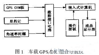
Global Positioning System
The GPS consists of a GPS-OEM motherboard, a data conversion board, an antenna, and a power supply.
At present, many manufacturers can provide GPS-OEM board products, such as SiRF, Conexant, Sych ip, GARM IN and other companies. Among them, the US GARM IN company is the world's most famous professional GPS manufacturer trusted by users. It has been at the forefront of the world in the field of GPS positioning and navigation. Due to the fast positioning speed, stable operation, voltage shock resistance and high anti-interference of the GARM IN OEM board, this solution uses the GPS15-LVC board produced by GARM IN.
The data conversion board is connected with the GPS-OEM board, and the function is to receive the original data of the GPS motherboard, extract the required data and convert it into the data format required by the user machine, and send it to the user machine through the serial port.
Dead reckoning system
The dead reckoning system consists of angular rate gyro, odometer, low-pass filter, V/F converter, level shifter, counter, microprocessor, communication line and other hardware. The direction sensor uses angular rate gyro, distance sensor. Use an odometer.
The dead reckoning method is a commonly used autonomous vehicle positioning technology in which heading and distance sensors are used to measure the displacement vector to estimate the position of the vehicle. The position of the vehicle at time tk can be expressed as:
![]()
Where (x0, y0) is the initial position of the vehicle at time t0, (xk, yk) is the position Si of the vehicle at time tk, and θi is the position of the vehicle from the position (xi, yi) at time ti to the time ti+1, respectively. The length and absolute heading of the displacement vector of (xi+1, yi+1). The relative heading is defined as the difference between two consecutive headings, denoted by Xi. If the relative heading measurement Xi at times t0, t1, and tk is given, the absolute heading θk of the vehicle at time tk can be calculated by:
![]()
Map matching
The map matching algorithm uses a method of probability determination. The system must know the position of the starting point and the heading angle. The heading change usually given by the rate gyroscope is compared with the map features near the expected position of the vehicle. When the measured significant change of the heading of the vehicle is related to the vector route change of the digital map, the real position of the vehicle can be on the map. determine. The drift error of the sensor can be corrected according to the specific position of the vehicle, and the error such as the wheel diameter error is calibrated. The correlation map matching algorithm works best when there is a large change in the heading of the vehicle (for example, when the vehicle is turning at an intersection).
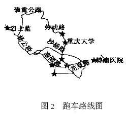
test results
In order to verify the positioning accuracy and reliability of the system, compared with the performance of the GPS system and the GPS/DR combination system, an electronic map was created using a 1:500 scale map, and the sports car route was selected as shown in Fig. 2 to carry out a sports car test. The obtained test results show that when GPS positioning is performed alone, the obtained positioning trajectory is discontinuous and there is an "upper room phenomenon". When combined with GPS/DR, the positioning trajectory is continuous and always on the correct road.
in conclusion
The GPS/DR combined vehicle positioning and navigation system combines GPS and DR to improve the system's effectiveness, integrity and accuracy. The DR trajectory estimation system can ensure the vehicle position information output when the satellite signal is lost, and the map matching technology can be used to further improve the accuracy. The system has all-round, all-weather, unobstructed and high-precision features, and has a good application prospect.
Guangzhou Ehang Electronic Co., Ltd. , https://www.ehangmobile.com